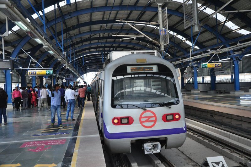
The Delhi Metro is an inexpensive, fast and comfortable form of transport that allows you to move between all, even the most remote, urban areas. And while it is possible to find yourself in a stampede when boarding a car or in the car itself, it is much better than moving around the extremely polluted Indian capital on foot, by bus or taxi – the metro in Delhi is very modern and always clean, especially compared to other facilities in this country.

Interesting fact! In terms of the length of metro lines, Delhi ranks 8th in the world, and 18th in terms of passenger traffic. Approximately 2,500,000 passengers use its services every day.
Using the Delhi Metro has a number of advantages:
- The Delhi Metro map helps you not only use its services safely, but also easily navigate the huge city.
- Metro lines connect the entire territory of the city with the most important railway stations and the airport. This scheme is convenient for travelers: after getting off the plane, you can take a train and get to your hotel or to the necessary railway station to continue your journey.
- You can take the metro to almost all the most popular attractions in Delhi marked on the city map. And due to the fact that many kilometers of rails are located on overpasses, when moving the train, you can look at the capital of India from a height.
General information about the Delhi Metro

In the 80s of the twentieth century, the Delhi city authorities proposed the need to build a completely new transport system that could combine underground metro lines and suburban trains into one. The plan and schemes of such a system were developed until the end of the 90s, after which they began to implement it.
The first branch (shown in red on the diagram) was launched in the early 2000s, and the next one was opened 2 years later (shown in yellow on the diagram). In total, in the 2000s, approximately 60 stations were built and 65 km of tracks were laid. The expansion and completion of the Delhi Metro is constantly ongoing, and this process is carried out at a very rapid pace. To better assess the speed of construction, you can compare metro maps for different years of its existence.
The first pieces of track put into operation have a track width of 1676 mm, which corresponds to the standards in force in India. Sections that are put into operation later have a narrower track that meets European standards.

Currently, the Delhi Metro is operated by DMRC Transport Company. 300 trains are involved in passenger service, some of them have 4 cars each, others have 6 or 8 cars each. All cars are air-conditioned.
The Delhi Metro has one interesting feature: car number 1 in any composition is intended exclusively for women! Although no one forbids women to travel in other cars, which they do, especially if they travel not alone, but in families.
Metro map: lines and their features
The metro network covers Delhi very tightly. It has 8 lines with a total length of 342.5 km and 250 stations. Only in the central part of New Delhi, the tracks run underground (only 3 branches), and in other parts of the city they are laid on overpasses, over highways.
The New Delhi metro maps are located at all stations, they will help you get the right route and accurately choose the right direction.

A tip! On the walls of the Rajiv Chowk central station there are special stands with pockets, which contain current schemes of the Delhi metro. You can take them completely free of charge – they will always help you navigate in the metropolis.
The orange line of the New Delhi Metro leads to the airport, but you need to know that there is an Airport and Delhi Aerocity. Airport is the 3rd terminal of an international airport, while Delhi Aerocity is a domestic airline terminal.
If you look closely at the map of the transport system, you will clearly see that some of the branches are bifurcated. In this regard, you should always listen carefully to the announcements in order to know exactly where the train is going. For the same reason, it is necessary to read the information that is displayed on the scoreboard. Let’s take an example of the situation with forking branches. If you need to get from RK Ahram Marg (in the diagram it is located on the blue branch) to Akshardham (in the diagram it is also on the blue branch), then you will have to go to Yamuna Bank and make a transfer there (you do not need to buy another token). When the next train arrives, an announcement will sound (and information will appear on the scoreboard) where it should go: to Vaishali or to Noida City Centre. To get to Akshardham, you will need to take a train that goes in the direction of Noida City Center.

A tip! The lines are laid out so that almost all city attractions can be reached by metro. At the same time, it is very convenient to navigate, since many stations located near significant places in Delhi have the same name: “Red Fort”, “Kashmir Gate”, “Parliament House”.
Special attention should be paid to the transport system of Gurgaon and Noida – these are two satellite cities of New Delhi. The subways of these cities connect to the metro of the Indian capital, and you can transfer to them on the Delhi metro lines, which are indicated in yellow and blue on the diagram.
A tip! For a convenient and correct transition from branch to branch, special “tracks”are pasted on the floor of the stations. They match the color of the desired branch and lead directly to the goal.
The Delhi Metro continues to build and expand, creating up-to-date maps. That is why it is advisable to check all available information. An up-to-date map of metro lines can be found on the Delhi Metro website: www.delhimetrorail.com
Working hours and travel intervals
On the line that connects the city to the airport, train service starts at 4:45 am, and on all other routes – at 5: 30. The metro ends its work at 23: 30.

Trains run at intervals of 5-10 minutes, and during peak hours the interval is reduced to 2-3 minutes.
Cost of travel
To use the metro, you need to purchase a token or travel card.

With tokens, everything is simple: they are sold at ticket offices located at the entrances to the metro. Since the cost of travel directly depends on the distance (the further you go, the more expensive it is), you must clearly tell the cashier the name of the destination when making a purchase. Each ticket office has diagrams of the Delhi metro lines, which indicate prices-they range from 10 to 50 rupees, only the fare to the airport from the center of Delhi costs 60 rupees. Perhaps the biggest drawback to purchasing tokens is waiting in queues that can last for 30 minutes.
If you are planning a long stay in Delhi, then it is more profitable and convenient to purchase a travel card (sart card), It is called a Travel Card, and you can buy it at information kiosks near the entrance to the metro. The price of a transport card is 150 rupees, with the card itself costing 50 rupees, and 100 rupees is spent on paying for travel. If necessary, the travel card can be repeatedly replenished at ticket offices or vending machines. The Travel Card is valid for one year, but when you leave Delhi, you can return it and get back its value (50 rupees).

Guests of Delhi are offered to purchase a Tourist Card, which allows you to make any number of trips on all metro lines, except for the express train to the airport. There are 1-day tourist cards for Rs 200 and 3-day tourist cards for Rs 500, and this amount also includes Rs 50, which is refunded when the card is handed over.
A tip! Buying tourist cards is absolutely unjustified and it is much more profitable to purchase a Travel Card, which is bought for themselves by local residents of the capital of India.
On the official website of the Delhi Metro http://delhimetrorail.com/metro-fares.aspx you can find out the exact cost of travel between specific stations, as well as any possible changes in the cost of a travel card.
Rules for visiting and using the metro
- A tip! While waiting for the train on the platforms, all passengers must line up-only in this order will you be able to enter the car. In Delhi, the problem of jostling was solved in this way.
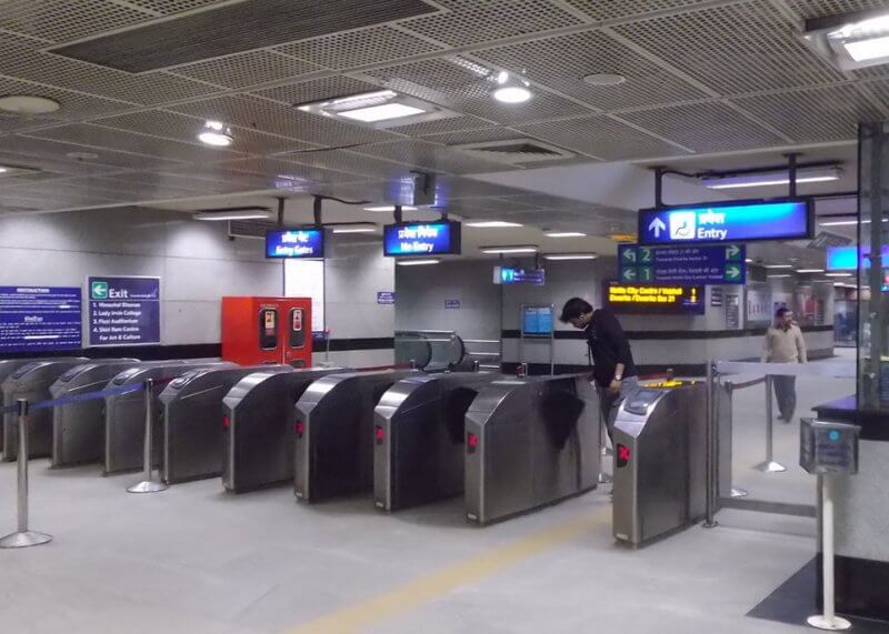
- You need to be prepared for the fact that the metro security service conducts a personal search of all passengers in the same way as at the airport. Police officers “shine through” all the luggage, and passengers are checked with a metal detector.
- To enter the metro system, attach a token or travel card to the reading equipment on the turnstile. To get out of the subway, you need to repeat the same action with the card again, and throw the token into the slot on the turnstile.
- It is forbidden to take photos or take videos in the Delhi metro (but if there are no police officers nearby, this can be done very easily).
- In contrast to the CIS countries, where it is customary to stand on the escalator to the right, and on the left you can go up or down on foot, in India it is the opposite. On the escalators here are on the left, and go to the right-in the Delhi metro, even the corresponding signs hang on the walls, “Please Keep Left”.